On the way to the glacier, we had to pass to the outside of a restricted area (marked by buoys and their resident sea lions) for the terminus of the Alaskan Pipeline. The terminus is in the background of this photo. Boats are not allowed inside the buoys, and tours were discontinued after 9/11 so this is the closest tourists can get:
These Italian photographers (and a videographer) were filming a documentary on our trip. They were very rude, and thought nothing of pushing aside the other people on the boat to get a photo. I had no respect for them whatsoever: Most trips to the glacier can only get as far as the terminal moraine, some 12 miles from the actual nose of the glacier. The terminal moraine is a pile of dirt and rocks that the glacier pushed in front of it, and it remains at the point that the glacier began its retreat. In the case of the Columbia Glacier, the terminal moraine is now underwater. But because it is a small underwater hill, only 30-40 feet under the surface, it tends to catch icebergs on its edges. These icebergs then form a barrier for boats traveling up the waterway.On our trip we got lucky -- the normal iceberg barrier was gone, so we were able to get very close to the glacier, within .8 mile. Even the crew was excited -- they told us only about 100 people had ever gotten that close to it!
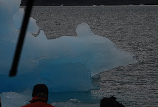
A bright blue iceberg out the front window of the boat:
Capturing an iceberg to bring on board: As we got closer to glacier, the trip became more and more like traveling through a 7-11 Slushy. The temperature dropped to 45 degrees, but the wind chill made it seem more like 25. We saw seals and sea lions on bergs everywhere -- apparently the orcas don't like navigating the icebergs so sea life is safer here. When we got close to the glacier, it was a wall of fractured ice 400 feet high. The glacier also extended about 400 feet below the surface of the water, where the most melting occurs. Once the ice is undercut, large chunks break off. This is called "calving," and we did see -- or mostly heard -- one huge chunk plunge into the water. The dark lines in the glacier are dirt and rocks that it collects on both sides. When this dirt and rock is deposited as the glacier retreats, it is called a lateral moraine.When two glaciers come together, as they do here, lateral moraines meet in the middle and this accumulation of dirt and rocks is called a medial moraine.
Sometimes a chunk of glacier with dirt stripes intact breaks off. In this photo, you can also see how the water has undercut the iceberg: When we got to the point that the water was filled with this much ice and slush it was time to return: It was a wonderful trip, and a one of the highlights of our trip to Alaska.


