Wednesday, April 30, 2008

Petroglyph National Monument

Location: Albuquerque, New Mexico

Click for Larger Image of Lava Flow150,000 years ago, a group of peaks named Albuquerque's Volcanoes erupted for the last time. Now reduced to short cinder cones, they once produced long lava flows that eventually cooled and cracked into rocks that tumbled and rolled down the slopes of what is now a mesa. Eventually, oxidation weathered the rocks to a dark brown patina.
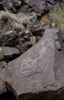
Click for Larger Image of Macaw PetroglyphFast forward 148,000 years, and humans now occupy this land. From 2,000 to 400 years ago, American Indians and Spanish settlers removed the layer of patina to create images, or petroglyphs, in the rocks (pictographs are similar, but are created using paint on rocks). Some are recognizable as humans, birds, or plant parts, while the meaning of others is unknown. The relative age of the petroglyphs can be determined by color and order -- the older petroglyphs are fainter and darker, as the patina has begun to reform. Newer petroglyphs may overlap older ones, creating a time line.

Click for Larger Image of Human Figure Petroglyphs

The petroglyph above shows two macaws, one free and one that appears to be in a cage. Macaws have long, plumed tail feathers, and these were commonly used in Pueblo Indian ceremonies. The photo on the left shows human figures. The fainter one on the right has been overlaid by a face in a star, possibly a mask, with a headdress and talons. One eye of this image has been recently vandalized, a federal offense.

Click for Larger Image of Volcanos From PetroglyphsThe trail in Petroglyph National Monument took us to the top of the mesa, where we could see the cinder cones that are the remnants of the volcanoes that created this landscape, now looking like three dimples on the horizon. There are over 20,000 petroglyphs in this area, and archaeologists are still developing methods of dating them and determining their meaning. But ponder this -- what if they are just ancient graffiti, with no more meaning than the pictures and words we try to ignore as we hurry under overpasses or pass by construction zones? It would be sad to think of a future archaeologist trying to find deep meaning in the messages our graffitti artists are leaving -- using, of course, the medium of spray paint instead of a chisel and rock.

Sunday, April 27, 2008

My Second Visit to Mexico

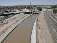
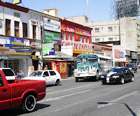
Click for Larger Image of the Rio GrandeEl Paso, Texas, sits at the intersection of Texas, New Mexico, and Mexico. It is a large, metropolitan city, and we finally found the Mexican border crossing after driving aimlessly around several city blocks at the southern edge of town. After a short walk across the covered pedestrian part of the bridge, we were in Juarez, a town famous for... well, not much you've ever heard of except bull fighting, murders, and illegal drug trafficing. Here the Rio Grande is encased in concrete and ringed with barbed wire, armed border guards patrol both sides of the bridge, and everyone does not speak English. While I would not want to be there after dark, my friend Cookie and I walked across for an afternoon of shopping and Margaritas, and felt safe as long as we didn't stray from the major streets.

Click for Larger Image of the Border Crossing Facing El Paso US There were a lot of people walking from the U.S to Mexico, and many of them appeared to be Mexican citizens. We did a bit of a double-take when we realized they had been shopping in the U.S. Aren't the bargins supposed to be on the Mexican side? Crossing on foot from either side takes only minutes, but by auto it can be much longer -- we saw long lines of cars and busses waiting to pass through U.S. customs.

Here are some photos from the trip. The last photo was taken as we took a refreshment break in a restaurant. Our waiter, who was kind enough to direct us to the safer sections of town, also supplied a couple props and took this photo. No, we didn't keep the hats!

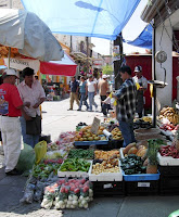
Click for Larger Image of Juarez Street Scene Click for Larger Image of Juarez Street Scene Click for Larger Image of Juarez Street Scene Click for Larger Image of Juarez Street Scene Click for Larger Image of Juarez Street Scene Click for Larger Image of Juarez Street Scene Click for Larger Image of Juarez Street Scene Click for Larger Image of Cookie and ZoAnn in Restaurant, Photo Taken By The Waiter

Friday, April 25, 2008

Beep Beep Recycled

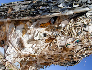
He -- or she -- lives in an eastbound rest area outside of Las Cruces, New Mexico and watches over the traffic speeding below. Twenty feet tall, with a belly made of old shoes, and a body made of... just about anything normally found in a dump. Scrap metal, telephone cords, old tires, and even a computer keyboard form the rest of the body, the head, the huge feet, and the tail feathers. Did I mention this is a giant roadrunner? Wile E. Coyote doesn't stand a chance.


Click for Larger Image of Roadrunner and ZoAnn, Shot By Cookie
Click for Larger Image of Roadrunners Head
Click for Larger Image of Detail of Roadrunner
Click for Larger Image of Roadrunner With Highway Below

Wednesday, April 23, 2008

White Sands

Location: White Sands, New Mexico

Click for Larger Image of Dune EdgeAs we came down from the mountains on our way to White Sands, we found ourselves in a large, flat valley that turned out to have its own place in history -- it's the alternate landing site for Space Shuttle, and, more somberly, the place where the Atomic Age began on July 16, 1945. Now called White Sands Missile Range, 63 years ago it was Trinity Site, where the first atomic bomb was detonated.

As we crossed the valley, the sand dunes began abruptly. Little dunes did not change into big dunes, and sand did not gradually build as we travelled -- the dunes weren't there, and then suddenly they were (you can see their edge in the photo above). They cover an amazing 275 acres, but easy public access is limited to an 8 mile drive, part paved and part packed sand. The rest is open to those willing to hike or backpack in beautiful, but brutal conditions. A compass, water, sunscreen, good shoes, and a fair amount of outdoor skills are needed -- getting lost and disoriented is amazingly easy. We stopped at the trailhead of a 1-mile hike, and I walked far enough to be out of sight of the car. The "trail" disappeared, replaced by rolling dunes that all looked alike. There was nothing but sand, heat, cacti, and silence. The sun was high in the sky, and directions became meaningless. Other than a few other human visitors, the only living thing I saw was an ant. Other things -- insects, lizards, small mammals -- do live there, but they don't come out during the heat of the day.

Click for Larger Image of a DuneThe sand is very, very white and soft. It is actually gypsum, carried into the Tularosa Basin by rain and snow that starts high up in the mountains. The Tularosa Basin has no outlet, but evaporation removes the water and leaves the gypsum. Eventually it weathers into sand particles that are light enough to be moved by the wind. The dunes are constantly in motion, ever changing and moving approximately 6 inches a year.

Click for Larger Imae of Sand DriftsThe sand reminded me of the snow I saw so much of in Michigan. Just like snow, the road is plowed, and the sand pushed up on the shoulders where it forms long vertical walls. Sand drifts accumulate on fences and start encroaching plowed areas. Roads that are not paved are solid white, and it becomes difficult to tell where the road ends and the dunes begin. The sand is so white and bright that your eyes will begin to hurt if you are not wearing sunglasses. The dunes also bring entertainment -- kids ride large, brightly colored plastic saucers down the dunes, then haul them back to the top to ride down again just like they do after a deep snowfall.

It is a lovely, place to visit but I wouldn't want to live here.

Sunday, April 20, 2008

The Gila Cliff Dwellers

Location: Gila National Forest, New Mexico

Click for Larger Image of New Mexico SceneryA distance of 72 miles in New Mexico means a huge change in the scenery. On Saturday, John, Cookie, and I started in Deming and drove north. We began in flat desert country; drove through rolling hills that were brown, dry, and covered in sage and cactus; passed through increasingly green terrain and large pine trees; and ended up in a low mountain range where the road narrowed, the center line disappeared, and hairpin turns and switchbacks became the norm. The view on one side was the cut in the hillside where rocks and trees were poised to fall without warning -- and one big rock in the road proved that they do, indeed, fall. The view on the other was a steep slope into a wide valley, only a flimsy guardrail and the car's brakes between us and a plunge to the bottom.

Our destination was the Gila Cliff Dwellings, part of the Gila National Forest. While this area has been occupied for thousands of years, for a short period of time humans built dwellings within the natural cliffs that overlook the Gila River. A small subgroup of people of the Mogollon (mo-go-yon) culture, probable relatives of the Zuni and Hopi, lived here from 1270 to 1300, and then moved on for reasons unknown.

Click for Larger Image of the Path to the DwellingsWe arrived at the park, stopped for shopping and a bathroom break at the Visitor Center, and then began the short hike up to the cliffs. The trail was a 1-mile loop, following a lower path up to the cliffs and returning by a higher path that descended just before the trailhead. Once we had climbed the 180 feet to the level of the cliffs, we got our first good view of the actual dwellings. They can be seen in the center of this photo.

Click for Larger Image of the DwellingThere are six dwellings, side by side, on this cliff. The ones used as residences were not open to the public, but we were able to climb into, and walk through the largest one, a ceremonial area dominated by a huge kiva. The rest of the cave was divided into several smaller rooms, some of which appeared to have been used for food preparation. The inhabitants cultivated crops, primarily corn, beans and squash, and hunted game. One room still had very tiny ears of corn, the actual size of the mature crop, littering the floor.

Click for Larger Image of Drawing of a Man on the Dwelling WallThere were two drawings on the walls. One was this red painting of the figure of a person. The other was a hand print. These simple little expressions of 700-year old graffiti artist make a human to human connection like nothing else can. You have to wonder about the person who stood here, hundreds of years ago, and put his or her hand print on the wall or sketched a little stick figure. Was it meaningful? Or were they just doodling out of boredom? Was it "naughty" or "nice" to scribble on the walls?

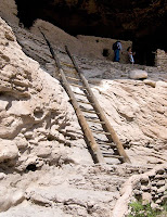
Click for Larger Image of LadderThe descent from the dwelling involved coming down a large wooden ladder, much the way the original inhabitants entered and left. Visitors with vertigo or those otherwise nervous about coming down the ladder could exit using the entrance stairs. I went down a few steps carved in the rock and took the ladder. Although it looked a bit daunting from the top, once my feet were firmly on the rungs it was an easy descent.

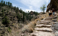
Click for Larger Image of Descending From CliffsThe hike back began with downhill steps cut into the rock, but soon became a dirt path with several switchbacks. Once we got down, we chatted with a volunteer ranger (who was also an RVer) for a while, and then took a different, but no less scenic way home, stopping for home-made ice cream on the way. It was a long day, but the beautiful scenery and the fascinating story of the cliff dwellers made it all worth while.

Thursday, April 17, 2008

New Mexico Signs

Here are some signs and places I found around Deming, New Mexico. Since the signs in the images can be small, most of them also have a close up image -- you won't need to squint to read them! If the detail image is not enough, you can, as usual, click for a larger image.

Click for Larger Image of Dog in Pickup and Dentistry Sign
Click for Larger Image of Dentistry Sign Detail
Click for Larger Image of Congested Area Sign on Backroad
Click for Larger Image of Congested Area Detail
Click for Larger Image of Stop Sign - Who is this for?
Click for Larger Image of Stop Sign Detail - Who is this for?
Click for Larger Image of Whoa Sign

Tuesday, April 15, 2008

My First Visit to Mexico

Click for Larger Image of the Border CrossingI am now staying at the LOW-Hi Park, situated 30 miles north of the Mexican border. Each week a large group caravans from here to Mexico to have lunch at The Pink Store in Palomas, a small border town that is mere inches into Mexico. About 40 of us parked on the U.S. side, and walked across the border. While cars are required to drive though a gate, the only real indication for those of us on foot that we were leaving the U.S. was a sign telling us we would be arrested if we brought firearms into Mexico, and a plaque with a vertical line that designated the exact location of the border. There were no uniformed officials asking for our passports and visas, or inquiring about where we were going or how long we were staying. We just walked right in.

The streets in Palomas are shabby and poor, but a few comparatively upper scale businesses -- opticians, dentists, and pharmacies -- joined The Pink Store as obviously U.S.-oriented. Most took either pesos or dollars and all took credit cards. A street vendor asked us if we wanted -- oddly -- plastic hammocks, another tried to sell us wallets and trinkets, and a man in a wheelchair solicited donations for a charity. A woman dressed in traditional Mexican garb held doors open for us, a basket pointedly in her hand for tips.

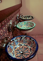
Click for Larger Image of The Pink StoreWe walked through The Pink Store to get to the restaurant. The store was overflowing with colorful goods like blankets, purses, small carved statues, jewelry, and liquor, all at bargain prices. Inside the restaurant, hot pink walls predominated, but the decorations were a confusion of color -- small stained glass windows and abstract glass art hung from the ceiling, mirrors and paintings competed for space on the walls, and a huge fountain gurgled in the middle of the dining room. Walls that were not hot pink were painted lime green or vivid purple. Even the restroom sinks and soap dispensers were mosaics of traditional designs and colors.

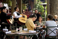
Click for Larger Image of sinksThe restaurant had a long table ready for us with hot chips, perfectly seasoned hot sauce, and excellent salsa -- just the right blend of tomatoes, onions, and cilantro. A one-man band played in the background, and occasionally diners would dance in the aisles. The first drink was free, so most of the group -- myself included -- ordered a Margarita. I usually expect "free" to mean "watered down" but not here! After lunch we shopped in The Pink Store, and then some in the group visited a pharmacy to pick up medications.

Once we were done eating and shopping, it was time to return to the U.S., where we did go through Customs. We showed our passports, declared our purchases, and were done with the formalities in less than five minutes. This was a fun first visit to Mexico for me -- made extra special by a great lunch and good company.


Click for Larger Image of John, ZoAnn, and Cookie - Image Taken By Another Diner

Dining At The Pink Store:

John, Me, and Cookie

Monday, April 14, 2008

Beep Beep

Location: Deming, New Mexico

Click for Larger Image of CampgroundI am currently staying at a campground in Deming, New Mexico that is primarily occupied by single RVers. As I travelled here from the Hill Country of Texas, I watched the colorful wildflowers along the road change to sage, and the rolling hills of grass and trees transform into rocks, sand, tumbleweed, and cacti.

Click for Larger Image of Desert Landscape The landscape here is desert. The days are hot -- in the 80s, but the temperature at night dips into the 30s or 40s. There is no water in the arroyos or streams, and hasn't been for some time -- many of the riverbeds have mature desert vegetation covering the bottom. Everything that is green is pointy and spiky, and even the cacti look thin and parched. The persistent -- and often annoying -- winds push tumbleweed against fences and trees, and what I normally think of as grass isn't anywhere to be found. They tell me that there were rabbits here that were eating the cacti. I haven't seen any, but others say the coyotes have driven them off. I haven't seen a coyote either, but I have heard them howling in the middle of the night.

Click for Larger Image of RoadrunnerThe State Bird of New Mexico is the Greater Roadrunner (Geococcyx californianus), and two of them frequent the campground, dashing across the rocks and through the cacti. They can fly, but usually choose to sprint instead. Shortly after I got here I asked one of the other women if anyone ever yells "Beep Beep" at them and she said, "only if we're drunk." When I finally saw one racing along, he was moving so fast that I could almost see Wile E. Coyote hot on his tail! I wasn't drunk, but I have to confess to "Beep beeping" him. It was irresistible.

Sunday, April 13, 2008

San Antonio

The Alamo


Click for Larger Image of the AlamoThose who fight, and sometimes die, for our country are without a doubt brave men and women. They go into battle knowing that they might not return. But those who fought at the Alamo took bravery to another level. They knew they would be horribly outnumbered and they knew there were no reinforcements coming. They knew they would die, and yet they stayed to fight.

The battle of the Alamo was fought in 1836 during the Texas Revolution, when Texas was fighting for independence from Mexico. In an attempt to quell the rebellion, General Antonio López de Santa Anna led 6,000 troops into Texas, surrounded the 187 defenders of the Alamo, and began to wait them out. The siege lasted for 13 days until, on March 6, 1836, Santa Anna ordered a pre-dawn raid on the compound. Those in the Alamo fought valiantly -- and in the dark -- but were overwhelmed almost immediately, and all but a handful of the men were killed. The few that survived were executed as soon as Santa Anna reached the battle field. The only survivors were 14 women and children who had taken refuge in the Alamo. They were each given a gold coin and a blanket, and then released so they could pass along the story of the conquest to the other Texian rebels.

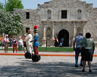
Click for Large Image of Photoshoot at the AlamoThe Alamo is considered to be a shrine to those who died there. When entering, visitors are asked to speak quietly and men are asked to remove their hats as a sign of respect. So what is going on outside? As I was leaving the Alamo, a group of photographers were gathering, diffusers and long lenses being unpacked as they fussed over two men dressed in Sergeant Pepper uniforms who were learning to ride Segways. ...What?


Click for Larger Image of Men and AlamoThe I have no idea why, but the Alamo was being used as a backdrop for this photo shoot. Once the two Lennon-McCartney wannabees had obtained a level of Segway proficiency -- to their credit, less than five minutes -- they sped off to the end of the Alamo barracks so they could be photographed rolling along the street, waving and smiling. Click, click, click. So much for decorum and respect!


Riverwalk


Across the street from the Alamo is one of many entrances to the absolutely lovely San Antonio Riverwalk. Both banks of the San Antonio River have been transformed into a strolling path, with lush vegetation, waterfalls, and quaint foot bridges to allow crossing from one side to the other. The businesses along the banks have open access at the river level, and boutiques, sidewalk cafes, and curious little shops compete for space. Water taxis ply the river, ducks and geese swim by, flowers of all kinds bloom everywhere, and mariachi bands play for margarita-drinking patrons. Everywhere the is water flowing, gurgling, falling, or fountaining. I didn't succumb to the lure of the margarita -- but I did have a dish of butter pecan ice cream as I strolled!

Click for Larger Image of Riverwalk  Click for Larger Image of Riverwalk  Click for Larger Image of Riverwalk

Thursday, April 10, 2008

The Texas State Capitol in Austin

Click for Larger Image of Texas Capitol BuildingMy friend, Cookie, and I decided to drive by the Texas State Capitol in Austin after we finished some chores in the area. It was almost dark when we got there, and each gate was guarded by a police officer. We asked if there was a place we could park to get a glimse of the building -- and not only were were invited to park inside the gate, we were told that the entire building was open! So in we went.

The building is laid out as most Capitols are -- a huge, central, open dome area with four wings housing the senate, house of representatives, and various offices. The wood is dark and ancient, the stairs curving and ornate, and the atmosphere a sweeping and elegant late-19th-Century chic.

Click for Larger Image of Looking Up the DomeThe area under the dome is an open atrium extending down to the first floor, and railings on each floor provide a safe viewing area. Visitors are not allowed above the fourth floor, but easily visible from any floor is the word "T-E-X-A-S" engraved around a huge star in the middle of the dome (click to view a larger image). On each floor, the walls of the circular halls are filled with photographs and paintings. The walls on the first floor have images of the most recent governors, including George Bush. There is enough blank wall space for seven more.

Click for Larger Image of Dome Floor The Texas State Capitol was originally built in 1839, but burned in 1881. The cornerstone for the current building was laid March 2, 1885 on Texas Independence Day. The building was dedicated in May 1888. While the top of the dome declares this to be "T-E-X-A-S," the bottom has inlays of the six seals representing the countries whose flags have flown over Texas. The countries are: The Kingdom of Spain, The Kingdom of France, The Republic of Mexico, The Confederate States of America, The United States of America, and The Republic of Texas. The Republic of Texas qualifies as a country -- after the Texas Revolution, Texas was a sovereign nation from 1836 to 1845. Its borders at that time included parts of New Mexico, Oklahoma, Kansas, Colorado, and Wyoming. These six countries are also the "Six Flags Over Texas" for which the original theme park in the chain was named.