Tuesday, April 28, 2009

The Best Little Whorehouse Inaccessible Lot in Texas

Location: La Grange, TX

Rumor spreadin' a'round, in that Texas town 'bout that shack outside La Grange


(And you know what I'm talkin' about)


Just let me know if you wanna go to that home out on the range.


(They got a lotta nice girls)


Well, I hear it's fine, if you got the time, and the ten to get yourself in.


And I hear it's tight most ev'ry night, but now I might be mistaken.


Have mercy.


------ ZZ Top, La Grange


The year is 1905 -- Theodore Roosevelt is President, Albert Einstein is working on his theory of Relativity, the first forward pass in American Football is thrown, a small town in Nevada called Las Vegas is founded ... and arguably the most famous "House of Ill Repute" in the country opens for business on the Colorado River in La Grange, TX.

Miss Jessie found a nice place just outside the town limits, and ran the business with local Law providing Silent Partner services. Business interests grew and grew (sorry, Intended Pun 1). Then in the 1930's the country was hit with what was then called simply The Great Depression, but unfortunately may now start being called The First Great Depression.

Her services were still in demand, but so many men had so little money -- but they had chickens! So the Chicken Ranch was born, charging one chicken for one lay -- which seems somehow appropriate (Intended Pun 2). Miss Jessie would then sell the chickens or the eggs at market.


Original Chicken Ranch (photo attribution unknown)


In the 50s, the ownership changed from Miss Jessie to Miss Edna. Miss Edna became the town's leading contributor to civic causes, retaining the close and mutually profitable working relationship between the Ranch and local law enforcement. The customers kept coming, and let me apologize now for Intended Pun 3! Chickens were no longer used as currency, the going rate being a competitive $15 for 15 minutes.

In 1973 the house was finally closed, but two years later customers were still pulling into the drive. The place has now been sold, the house demolished, and the entire affair mostly wiped off the La Grange map. There are no "Chicken Ranch Giftshops," "Chicken Ranch Condoms," or "Chicken Ranch Coloring Books" in this town. The back of the property can just barely be seen from a city park that looks over the Colorado River. The front is inaccessible -- upon turning into what was the drive, it becomes obviously and annoyingly clear that the Chicken Ranch has now been transformed into the Private Cow Pasture.


Chicken Ranch Property Today


If the story of the Chicken Ranch sounds familiar, it should -- this was the the legend that spawned both the play and the movie, The Best Little Whorehouse In Texas.

Monday, April 27, 2009

On the Way to San Antonio

We're now on the road, working our way from the desert to the Big Thicket area of Texas. On the way through Las Cruces, we stopped once again at the Giant Roadrunner (previous post here) made of trash who looks out over Las Cruces. He's dwarfing John in this picture. And here's a very short video I took that gives a close up view:


Then on to the town of Ozona, TX, the county seat of Crockett County -- an easy grab for them because they are the ONLY town in Crockett County. Most of the town has closed for lack of business, but they still have the huge statue in the town square (where the grass really needs cutting) in honor of Davy Crockett. The wisdom of Davy, immortalized on his statue is the helpful phrase, "Be sure you are right, then go ahead." Thanks, Davy.

Wednesday, April 22, 2009

Leaving Tucson

Tomorrow morning we leave Tucson, and will head east towards Texas. The Tucson area has so much to see and do that we reluctantly must leave some interesting things for another trip. Plus, the temperature in the last few days has reached, or almost reached, 100 degrees -- yes, it is a dry heat, but it has still been HOT.

In the last few days --

  • We met our friends Ruth and Tom who live here in Tucson for a fun evening -- a tram ride through the Sabino Canyon and a wonderful dinner at their house. Thanks, Ruth and Tom -- it was great seeing you!

  • We took a trip to the top of Mount Lemmon:

And along the way we saw hummingbirds and Saguaros in bloom:


  • And we have discovered how lovely the evenings are here -- sitting outside, watching the sun go down behind the desert cacti and then watching the stars come out. That's also when groups of quail run for cover (they seem reluctant to fly for some reason), the temperatures plummet from the extreme heat of the day to something cool and pleasant, and the coyotes begin to yip and howl. It's become our favorite part of the day.

Saturday, April 18, 2009

Another Crested Saguaro

After my previous posts about crested saguaros (here and here), I've had a few people ask why they grow the fan. It's an easy answer to a tough question -- no one really knows.

Botanists do know that the growing point of the cristate, or crested saguaro becomes multiple points which results in the fan-shaped top. Possible reasons include lightning strikes, freeze damage, or mutation. It is a rare condition - of the 1.6 million saguaros in Saguaro National Park, only 25 cresteds have been found.

The crested saguaro in this photo was inside the Desert Museum, a part museum, part zoo, part aviary (including a hummingbird aviary), and part botanical garden here in Tucson. Here are some more pictures from the museum:


Thursday, April 16, 2009

What's On The Lunch Menu

Location: Tucson, AZ

As I was walking along in the desert the other day, a movement on a small cactus branch caught my eye. It turned out to be this little moth, who was caught on the cactus' needles, fluttering its wings in a useless attempt to free itself. If I saw it, I imagine other creatures did, too, and the moth probably became somebody's easy lunch.


While strolling through a wonderful outdoor museum here in Tucson called the Arizona-Sonora Desert Museum, I came upon this Tarantula Hawk (Pepsis sp.), a very large wasp that -- and please stop reading NOW if the realism of nature's cruelty bothers you -- paralyzes a fully grown tarantula and drags it back to its nest so its larvae can dine on the still-living tarantula, avoiding the spider's major organs for as long as possible to keep the meat fresh. Ah, Mother Nature!

The stalking of a tarantula by a Tarantula Hawk can be seen on this video. A video of a Tarantula Hawk dragging an already-paralyzed tarantula can be seen here. This video will give you a sense of scale -- this is one of the largest insect you will ever see. And if you do see one, don't touch it -- the Tarantula Hawks' sting is on the top of the insect-sting pain scale. Oddly, however, it is New Mexico's State Insect!

Wednesday, April 15, 2009

More Crested Saguaros

Location: Tucson, Arizona

Saguaro National Park is actually in two separate districts, one on the west of Tucson, and the other on the east. As you would expect, the entire area has a lot of saguaros, but visiting the park itself had a special perk -- the rangers were a wonderful resource for pointing us towards the rare crested saguaros in the area, of which there are four.

This was my favorite -- it is in the eastern part of the park, about a mile down a desert hiking trail. This was the only one of the four to also have arms:


Here are the others -- the first one was also within the park boundary, but the last two were on private land (but easily seen from the road):


Friday, April 10, 2009

The Apache Trail and Tortilla Flat

Location: Tucson, AZ (where the call of the coyotes lulls you to sleep)


While we are now in Tucson, before we left the Phoenix area we took a drive on the historic Apache Trail. Once a stagecoach route through the Superstition Mountains (where the legendary Lost Dutchman's Gold Mine is said to lurk), the drive is now a gorgeous 40-mile trip on switchbacks and curvy mountain roads from Apache Junction to the Theodore Roosevelt Dam. Not -- I repeat, not -- a road for anything large like an RV!

We passed a few cars here and there, but the traffic was very light. We planned to have lunch in a restaurant in the small town of Tortilla Flat (population 6 -- and they actually have a post office and a voting precinct), but when we got there we had a surprise -- instead of a few lost souls around a dinette counter drinking oily coffee, we found the restaurant was filled with tourists!

People were dancing outdoors to a western band; they were panning for gold in the stream; they were eating "olde-time" candy and ice cream cones while sitting on benches; and they were dining on some of the hottest chili I've had in a long time.

The restaurant encourages patrons to write on dollar bills which are then stapled to the wall. I've seen this in a few restaurants before, but I have to say that none were as neatly stapled in rows and columns as Tortilla Flat! When we walked in, we saw this boy at the bar, finishing the scribbles on his dollar and eating fries. Interesting what sign he sat under, isn't it? (and it IS root beer he's drinking!)

Almost immediately after leaving Tortilla Flat, the road, which had been paved, became graded dirt. It narrowed, too -- a few times we had to pass cars going the other way, and it was a tight squeeze. For the most part, however, we had the road to ourselves.

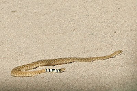
That is, until John brought the car to a screeching halt (as much as a car can screech on dirt) because this Western Diamondback rattlesnake was in the middle of the road. I took these shots from the safety of the car, and decided that I really would not want to meet one of these guys on a trail! His rattles are clearly visible in the first photo. For scale, notice the size of the tire track under the snake's head in the second photo.


The road alternated between traversing high mountains and low valleys, always following turns, hills, curves, and switchbacks. It took hours to go the 40 miles, but it is one of the prettiest day trips anywhere. In this photo, you can just barely make out the continuation of the road -- it's that little whitish line about in the center:


At the end of the road lies Theodore Roosevelt Dam, a 1903 construction that dams the Salt River and creates the Theodore Roosevelt Lake. It is the world's highest masonry dam, and originally cost $10 million to build. By the time we got there, it was starting to get late so we took the "fast" way home, on interstates, even though it meant going many more miles around the mountains. It only took us 2 hours to get back.

Tuesday, April 07, 2009

Pinnacle Peak

Location: Phoenix, AZ

I got to try out my "new" ankle on a short hike yesterday. We hiked about half way up Scottsdale's Pinnacle Peak, a 600 foot granite rock pile that was, like the boulders at Joshua Tree, formed by underground molten lava that was eventually exposed by erosion.

When we got part way up, we were suddenly surrounded by hoards of large black and orange insects, strangely flying with their abdomens held down. Most of them favored nearby bright yellow flowers, but some would land on us or "dive bomb" our heads. Talking was risky -- one would have flown into my mouth had it been open!

They turned out to be Blister Beetles, in the family Meloidae. Blister Beetles are so named because they secrete a poisonous substance called cantharidin. Cantharidin will blister human skin at contact, is medically used to treat warts, and is also known as "Spanish Fly." A few Blister Beetles unknowingly eaten by a horse can kill it.

The desert now has several plants in bloom. Ocotillo, cholla, and various cacti and flowering plants all have blossoms. Here is one of the cactus blooms from the hike:


Friday, April 03, 2009

Slab City

Location: Southern California, Salton Sea

While most RVers stay in campgrounds, there are those who love to find free, or almost free places that allow them to "boondock" or camp without water, electricity and sewer hookups. Overnight stays in a Walmart or Cracker Barrel parking lot are common (and are really not free -- RVers typically spend more in the store than they would have for a campsite); so are the almost-free Bureau of Land Management properties that are typically land that is of little use, so RVs are allowed to stay there for a very small fee.

Just off the Salton Sea, however, lies the last, really free boondocking site -- Slab City, also simply known as The Slabs. Originally a World War II Marine barracks, Slab City is now just what its name implies: acres of concrete slabs left in place when the barracks were dismantled. Whoever officially owns the property ignores it totally -- without available water, owning desert land is more a liability than an asset.

Living there is anarchy in its most basic form -- there is no government, no services, no rules. Electricity is manufactured through solar panels (see photo on left) or generators; water is hauled in from the nearest town, a depressing few blocks of nothing much in the middle of even less, and holding tanks are emptied by a service that comes through every so often. The local police make a drive-through only occasionally. People can, and do, die here unnoticed.

Although there are "neighborhoods" where specific groups congregate, RVers can park wherever they want and stay as long as they want. Most come for a few days to a few months in the winter, but there are some hearty souls who brave the 110 degree -- or more -- heat of the desert summer to live in Slab City year-round. Some of these residents are eccentric; some are downright crazy.

We took a day trip from LaQuinta to visit this infamous place. It was late March, and most of the snowbirds had left. What we found looked like a scene from a post-apocalypse movie, or the final confrontation zone in The Stand. Decrepit, misshapen RVs and vehicles dotted the landscape, some adorned with glittery objects and brickabrack, some rusted, paint peeled away in strips and lacking hoods or fenders. They had obviously not been moved in years, if not decades. In many cases, the leftovers from living life in the desert stayed where they had fallen -- trash, broken appliances, and heaps of unidentifiable "stuff" adorned what would, in another world, be called their "yard." Dogs guarded this mess as if it were gold.

There were signs that The Slabs might be a bit more comfortable and friendly during the winter season -- there were at least three social clubs in operation, although they were little more than discarded sofas arranged outside ramshackle RVs. There was a church, a solar panel business, and even a pet cemetery where paw-shaped paving stones and decorated rocks marked the graves of these deceased family members. At least we hoped it was a pet cemetery!

A bit before you enter Slab City, you are confronted with Salvation Mountain, a huge painted rock that is covered in Bible verses. The painter, Leonard Knight, has been working on this labor of love for over 20 years. It seems to fit nicely here.

Slab City is unique in Americana. It is interesting and somewhat compelling, but foremost it is creepy and disturbing. I'm sure there are some very nice people who live there, but I have to wonder if the crazy ones came to the Slabs that way or were unavoidably transformed by this odd and undeniably freaky existence. Feel the need to surround your plastic Santa with concertina wire? If yes, you might consider relocating to Slab City!

Wednesday, April 01, 2009

Joshua Tree

Location: Joshua Tree National Park, CA

What I expected from Joshua Tree National Park was a desert landscape populated by the somewhat odd Joshua Tree, where one could drive through several miles of improved roads and marvel at the number of these trees in one location. What I got was a lesson in geology.

Coming in from the south, the first thing that jumps out at you is that Joshua Tree National Park is totally devoid of any Joshua Trees. The Visitor Center has a large helpful sign that explains that there really are Joshua Trees in the park, they are just further north. What this area does have is some lovely desert scenery with patches of ocotillo and cholla. The ocotillo, a desert plant with long, spikey "leaves" extending upward for 8 feet or so, was infrequent on this drive. However, the cholla garden, a huge area where the cholla have all but taken over the desert, was amazing. The photo on the left shows a cactus in bloom in front of a small part of the garden.

As we moved north, we passed from the Sonoran Desert into the Mojave Desert -- a transition that might, at first guess, seem to be much ado about nothing. But the vegetation was somewhat different, and we began to see more rounded piles of rocks and, at last, Joshua Tree forests. The rounded piles of rock turn out to have a very interesting geological explanation. They formed eons ago as magma-filled underground chambers. As it cooled, vertical and horizontal cracks formed. As the ages wore on and the topsoil eroded, the rocks were exposed to weathering in a climate that was wetter than today. As an ice cube held under water will first become rounded, so have the edges of the cracks become rounded, resulting in many sphere-like boulders still contained in the original shape of the mound.

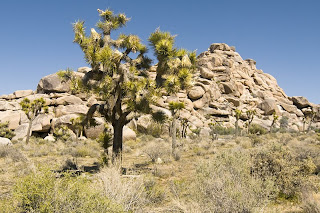
The topsoil now has totally eroded and, over time, exposed the magma chamber to our view. The edges of what was the chamber are dark rock while what was the magma -- technically called monzogranite -- is light. On some hills, you can actually see the edge of the magma chamber with some monzogranite still clinging. Look beyond the Joshua Trees in this photo -- the white rocks on the far hill are the monzogranite, while the hills themselves are all that is left of the then-underground magma chamber walls.

There are also lovely views of the Coachella Valley from the park. This valley is part of the tectonic plate boundary that includes the San Andreas Fault, the Salton Sea, and the Sea of Cortez -- and which will be, millions of years from now, a new ocean as the plates' junctions beneath the valley continue to expand. In this photo, the Salton Sea is just visible as a light streak on the far right: