Tuesday, May 27, 2008

Memorial Day Snow in Bryce

Location: Bryce Canyon, UT

Last week, in Zion, the high temperature was 105 degrees. In Bryce, on Memorial Day, the low was 25 degrees. What a change!

Click for larger image of Bryce in the snowAs we had planned months ago, I met Ken and Pam (see blog entries here and here) in Bryce, and my friend John is also here. The four of us hiked a loop trail in Bryce Canyon on Sunday, and then on Monday, Memorial Day, we hiked from the rim down to a small town named Tropic. Ken had lived there for a short time when he was a boy, and this was a hike he remembered fondly from his childhood. We began the hike in the morning, and within minutes a light snow started falling. How ironic -- we were hiking to a place named Tropic in the snow!

Click for Larger Image of Thor's Hammer in Bryce CanyonThe first indication that we were about to have a winter wonderland experience was when we saw the farthest hills and hoodoos softly fade into a misty white. Then the flakes began falling all around us as we navigated the switchbacks and trails going down from the rim. As we descended, the temperatures rose somewhat, and by the time we reached the bottom the snow had stopped, the sun was shining, and the temperature was pleasant. The rest of the hike was on flat terrain, through forests and shrubs, with the occasional sightings of chipmunks, lizards, and spring wildflowers.

We had dinner at Bryce Lodge, and then walked out to the rim for a last view of the canyon. (Tuesday we will all be traveling to Moab, UT). We asked a passerby to take out photo in front of the Canyon. From left to right, John, ZoAnn, Ken and Pam:Click for larger image of John, ZoAnn, Ken and Pam

Sunday, May 25, 2008

Hoodoos

Location: Bryce Canyon, UT

Bryce Canyon is not, technically, a canyon -- a canyon is carved from a single river, and, while the geology of Bryce does involve erosion by water, a single river was not responsible.

Instead, the land was uplifted and then water from several streams and lakes carved the landscape 63-40 million years ago. The rounded pillars, or hoodoos, have been chemically weathered by a weak solution of carbonic acid which forms when rain combines with carbon dioxide. The carbonic acid gradually removed the softer limestone and rounded the rock's sharp corners, leaving the hoodoos standing like sentinels.

Bryce Canyon is also a part of the Grand Staircase, a series of "steps" that increase in elevation from the lowest at the Grand Canyon (around 7000 feet), through the middle elevation at Zion, to the highest here at Bryce (around 8000-9000 feet).


Click for Larger Image of Bryce Canyon

Thursday, May 22, 2008

Zion

Location: Zion National Park, Utah

Click for Larger Image of My RV at Zion Just After DawnIt is hard to capture the enormity of the Grand Canyon -- it is too wide, too deep, and too immense. Likewise, Zion is difficult to capture, but its immensity goes in the other direction --up, and around, and up some more. It is one huge hunk of rock in front of other huge hunks of rocks, surrounded by more hunks of rock -- and they all take turns being in the foreground or fading to the back as the landscape changes and evolves with each turn in the road or trail.

Click for Larger Image of Angels Landing TrailOne spectacular hike is to Angels Landing, approximately at the top of the mountain in the photo to the right. The trail begins at the river, ascends to, and through, a canyon and then follows switchbacks to the top. Once at the top, the trail narrows and continues over steep rocks where chains have been bolted into the rockface to assist hikers. We made it half way through this final section, and then returned to the trailhead. We hiked almost 5 miles, gained 1488 feet, and had amazing views of the canyon.

Here are additional photos of Zion:

Click for Larger Image of Zion

Saturday, May 17, 2008

California Condors and More Grand Canyon Images

Location: Grand Canyon, Arizona

Click for Larger Image of California Condor (all three images are of the same bird. The red mark is a tag)Against the odds, the California Condor today soars over the Grand Canyon. These condors were plentiful in Arizona during the Pleistocene (50,000-10,000 years ago), but changing habitat and food sources reduced the population by the time European explorers came here in the 1500s. By the late 1800s, gold miners killed many of the remaining condors for their feathers, and entrepreneurs took their eggs to satisfy a Victorian fad for egg collecting. In 1924, the last Arizona condor was sighted in Williams, 60 miles south of the park.

By the 1980s, the remaining west-coast condors were dying from ingesting man-made poisons, flying into power lines, or eating animal carcasses that had lead bullets still within the flesh. 22 individuals were all that could be found, and a captive breeding program was begun to try to save the species. In 1996, the first California Condors were released into the wild. Two breeding populations have now been established: one here in Arizona, and one in Central California. They have had to learn how to be "wild," and there have been failures -- but the 50 California Condors that now fly over the Grand Canyon testify to the cautious success of the program.

Note: This photo is three views of the same bird. I once saw six flying at the same time, but more often I only saw one or two, if I saw any.

Here are other images of the Grand Canyon. Mouse over the image for more information, and, as usual, click for a larger image:

Grand Canyon Images

Click for Larger Image of the Grand Canyon  Click for Larger Image of Clearing Snow Storm  

Bright Angel Trail Images

Click for Larger Image of the Beginning of Bright Angel Trail, showing switchbacks. At the bottom, the trail will continue to Plateau Point (see next image). This is the trail both hikers and mule riders descend.  Click for Larger Image of the Bright Angel Trail, Indian Gardens (water stop and hiker campground, where the dark green trees are), and Plateau Point  Click for Larger Image of people hiking the switchbacks at the beginning of Bright Angel Trail  Click for Larger Image of people at the Bright Angel Trail tunnel  Click for Larger Image of mule riders returning on Bright Angel Trail. They will make one more switchback before reaching the last straight stretch to the corral  Click for Larger Image of mule riders returning to beginning of Bright Angel Trail and the corral  

Wednesday, May 14, 2008

My Mother, The Horse -- My Father, The Jackass

Location: Grand Canyon, Bright Angel Trail, Sitting On A Mule


"You can train a horse to run off a cliff... a rider can't get a mule to do it. They are less likely to think that what you want is in their best interest."

---Casey Murph, Mule Operations Manager

A mule is the offspring of a horse mama and a jackass daddy. They look more like a horse, but don't act like one -- they are safest and happiest when they are not engaging in independent thinking, but are following along, closely behind the mule in front. When they are nose-to-tail they keep moving and aren't distracted by things like hikers, small animals, or a new rock that might have fallen on the trail since their last canyon trip and would need to be fretted over if they had time to contemplate it.

Click for Larger Image of ZoAnn at Bright Angel TrailheadThe Grand Canyon offers two types of mule tours -- one is an overnight trip to Phantom Ranch, on the bottom of the canyon. Reservations are typically booked a year in advance. The other is a one-day, 12 mile round trip on the Bright Angel Trail, ending at Plateau Point. Since I didn't book Phantom Ranch last May, I went on the Plateau Point trip. Normally there are about 20 people on this one, but today there were 33 -- the trip to Phantom Ranch yesterday (the snow day) was cancelled because the mules were no longer shod in their "snow shoes," so many of those riders opted to join us on the one-day today. This photo of me at the trailhead was taken by one of the Phantom Ranch riders. See that narrow ledge down and to my right, between the two rows of lighter rocks? That's the trail the mules (and hikers) start down.

Click For Larger Image of our Waiting SteedsWe met at 7:00 a.m. to hear what to expect physically (primarily knee pain, "elsewhere" pain, and fatigue) and to receive mule handling instructions. We were issued a "mule motivator" (crop) to keep them moving forward if they dawdle, and were assured that their hide is very tough and there is no way we can hurt them. The mules were all brought to a corral near the trailhead, and we were divided into three groups, each with two guides, one to lead us and one to bring up the rear. I was given a male mule named "Mister," and he turned out to be a very good mule indeed. He always kept close to the mule in front of him without any "motivating" from me, and only occasionally tried to grab a snack from vegetation along the trail. We got on the mules, a not-so-pretty sight in many cases (mine included) -- they are large animals, and many of us needed a "butt boost" to get in the saddle. But somehow we all got on, and started out.

Click For Larger Image of Plateau Point From The Beginning of the Trail
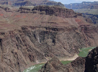
This picture is the view of our destination shortly after we got on the trail. You may need to enlarge it to see the trail in the center of the green triangle -- the end of it is Plateau Point. The mules know the way -- they spend at least five years in training, carrying supplies and trainers, and then they are evaluated for temperament before they are allowed to carry paying guests. They make this trip every day, and are sure-footed. They do tend to walk on the outside of the trail, but this was only scary for a short time. Once you go around a switchback or two, you realize that they know what they are doing.

On the way down, we stopped for a bathroom break and to fill up our water canteens at Indian Gardens, 1.5 miles before Plateau Point. Then we got back on the mules for the trip across the plateau, where yellow, purple, white, and magenta flowers were blooming along the trail. We had a box lunch at Plateau Point, sitting on the rocks and watching the rapids of the Colorado River below. Then back on the mules once again for the trip home. When we stopped again at Indian Gardens, everyone was hosed down to stay cool -- the temperatures in the valley can be 20-30 degrees warmer than at the top and it was now quite warm -- a big change from the low of 26 degree last night on the rim!

Here are some additional images from the trip. Mouse over the image for more information:


Click For Larger Image of My View From The Back of Mister   Click For Larger Image of Indian Gardens Rest Stop  Click For Larger Image of Mules Rounding Switchback; One in Tow That Couldn't Stay Close To The Mule in Front  Click For Larger Image of Horses Tied at Plateau Point  Click For Larger Image of the Lunch Ledge at Plateau Point  Click For Larger Image of The Colorado River From the Plateau Point  Click For Larger Image of My View on Mister, As He Looks at Other Riders Below Us  Click For Larger Image On The Trail  Click For Larger Image of Everybody Gets Wet to Cool Off on Return Trip  Click For Larger Image of Switchbacks From Trail Above  Click For Larger Image of Kim, Our Guide, and Mister After the Trip  

And, at the end of the trip, we were presented with a certificate welcoming us to the Order of the Master Mule Skinners of the Grand Canyon Trails. I then left the corral, walking stiffly, sorely, and a bit bow-legged, but not the least bit sorry that I went on this great adventure in the Grand Canyon, atop a good mule named "Mister." I'm just hoping that I'll be able to sit normally by tomorrow! Click for Larger Image of My 'Master Mule Skinner' Certificate

Tuesday, May 13, 2008

Just When You Think Spring Is Here

Location: Grand Canyon, AZ

For perhaps the first time in my life, I made it through November, December, January, February, March, and April without seeing a single snowflake (except those fake ones that Floridians inexplicably use in holiday decorations). Think I'd be safe by now, wouldn't you? Here's what I found this morning when I stepped outside:
Click for Larger Image of Snow on My RV

After I grumbled a bit about the cold and cleaned the snow off the truck (using a plastic bowl), I headed out to the canyon to see what it looked liked covered in a soft, gentle, blanket of snow. And this is what I saw:

Click for Larger Image of Grand Canyon Fog

The closer I got to the Canyon, the foggier it got until I reached the rim where the visibility was somewhere around zero. But I waited it out, and eventually the sun began to break through the fog. The snow was limited to the the rim -- the altitude here is about 7000 feet, and snow did not fall at the lower elevations within the Canyon. As the storm cleared and the sun came out, the colors of the canyon began to emerge:


Click for Larger Image of The Sun Coming Out
Click for Larger Image of Fog and Trees
Click for Larger Image of Sunstreaked Grand Canyon

Except for some shady areas, the snow is now gone. The cold weather will continue through tonight, with a low of 26 expected. But May is set to return within the next few days, and I really hope this is the last snowfall I see for a while.

Monday, May 12, 2008

The Grand Canyon, Day Two

Location: The Grand Canyon, Arizona

The weather was still nice today, but the cold front started to creep in during the afternoon causing increasingly cloudy conditions. The canyon views were pretty early in the day, but the encroaching haze began to blur the horizon and fade the colors as the afternoon wore on. By early evening, the rain had begun.


Click for Larger Image of Grand Canyon Vista


Click for Larger Image of the Colorado River

At one location, I saw a woman who looked out of place for two reasons: one, she was in a bright red dress (shorts or jeans are the dress of choice here in Vacationland), and two, she was holding a violin. She purposefully strode to the edge and began to play, as if to serenade the canyon. It was such a surprise to see her, and a such a lovely moment. The onlookers behind her were not her only "audience," though -- scroll down for "the rest of the story."


Click for Larger Image of Woman Playing Violin
Click for Larger Image of The Rest of the Story

Another Really Big Hole

Location: The Grand Canyon, Arizona

Grand Canyon ViewI am now at the Grand Canyon in northern Arizona, and what an amazing site this is! I got to see a very small part of the park yesterday, but I'll be here for a week so I expect to see a lot more. Maybe more than I want to see -- the "S" word is in the forecast (snow!) for tomorrow -- and it may get to this elevation. Low temperatures are projected to be in the 20s for the next few days. The good news is that day temperatures will be nice. On Wednesday, I've booked a mule trip to the canyon, and the weather forecast is a party cloudy. Fingers crossed!

And here is a picture of me with my friend, John, at the canyon rim. It was taken by a Kind Passerby.ZoAnn and John at the Grand Canyon

Saturday, May 10, 2008

A Really Big Hole

Location: Meteor Crater, West of Winslow, Arizona

Click for Larger Image of Meteor Crater

Meteor Crater, 4000 feet in diameter and 570 feet deep, is evidence of the amazing damage an object from space, measuring only 54 yards across, can cause if it smashes into the earth from space. The object was a hunk nickle and iron, otherwise known as a meteorite, and it smashed into what would become Arizona 50,000 years ago.

The crater was assumed to be a volcanic crater for many years, but was eventually identified in the early 1900s as an impact crater by geologist Daniel Barringer. In his honor, the crater's official name is Barringer Crater, but it is commonly known simply as Meteor Crater. It is still privately owned by the Barringer family.

Click for Larger Image of View from Meteor CraterVisitors to the crater are not allowed to descend to the bottom, but it is possible to walk for a short distance on the rim. Looking towards Flagstaff's San Francisco peaks, with the road to the crater snaking in the foreground, it is apparent how high the rim actually is. The crater dwarfs everything in its vicinity -- in the first photo, people on a viewing platform (who are still above the crater's plunge to the bottom) are just dots when seen from the top of the rim. At the middle of the photo, a small fuzzy area is visible at the center of the crater. This is actually a six-foot high fence next to some old equipment that was used to drill cores.

Because the crater is in dry, arid land, it is the best preserved example of an impact crater on earth. There are many others that have been identified, however. Images of other impacts can be seen at http://www.solarviews.com/eng/tercrate.htm.

Wednesday, May 07, 2008

Winslow, Arizona

Well, I'm a standing on a corner


in Winslow, Arizona


and such a fine sight to see


It's a girl, my Lord, in a flatbed Ford


slowin' down to take a look at me


--- The Eagles, "Take It Easy"


Winslow, Arizona has two claims to fame. First, Route 66, the "Mother Road" that snaked from Chicago to Los Angeles, went right through the middle of it. And, second, the Eagles immortalized a single corner in that town, a guitar player standing on it, and a girl in a flat bed Ford. Winslow has not forgotten either one.

You can buy all sorts of "I Got My Kicks On Route 66" memorabilia, from street signs, to t-shirts, to shot glasses and every other kitschy souvenir. But instead of buying a just an item with the slogan, all you have to do is walk down main street and you will see the famous quirky route everywhere. From the little odd diners, to the fabulous Hotel La Posada -- originally a railroad stop-off, now ornate, elegant, eclectic, and possessing for some odd reason a huge metal camel at the entrance gate.

Click for Larger Image of Route 66 Cafe
Click for Larger Image of LaPosada Add
Click for Larger Image of La Posada Entrance, the Camel, and my friend John

But Winslow's biggest contemporary claim to fame is "Standin' On A Corner Park," where a life-size bronze guitar player notices the girl from the song, artfully reflected on a two-story mural behind him. A real flat-bed Ford sits in the street, just waiting for him to climb in, and an eagle perches in one of the upstairs windows.


Click for Larger Image of Sittin' on a Corner